Monday, December 20, 2021

Livable Streets Look Back 2021

Livable Streets Look Back 2021
By Eillie Anzilotti

How We Made San Francisco Streets Safer In 2021

As 2021 comes to an end, we're reflecting on everything SFMTA has done to make San Francisco streets safer for all.

But first, let’s wind back 50 years ago to 1971: the year the first bike lanes went in in San Francisco! The city’s first bike lanes on Lake Street came out of a community effort to calm traffic and make the neighborhood safer.

There’s an often-quoted expression that “change happens slowly, then all at once.” For San Francisco safe streets, 2021 is certainly in the “all at once” phase. Fifty years after the first bike lanes were installed in the city, we’re continuing to push the boundaries of what safe streets can look like in San Francisco. Here’s a look at some key progress from this past year:

Transforming the Tenderloin: In a neighborhood where every street is on the city’s Vision Zero High-Injury Network, we implemented a suite of projects to make the whole area safer. Some highlights:

  • Two Vision Zero Quick-Build projects: On Golden Gate Avenue, a new protected bike lane was added along with improved curb access for businesses, and Leavenworth was reduced from three travel lanes to two to promote safer speeds.
  • Pedestrian scrambles—which stop traffic in all directions to make it safer for everyone to cross—were implemented at 10 intersections
  • In a San Francisco first, 20 mph speed limits and No Turn on Red restrictions were implemented neighborhood-wide to improve safety.
  • Several COVID-19 response projects have evolved into permanent community features. A physical distancing lane on Jones Street, implemented to give people more space to walk during the pandemic, was turned into a permanent travel lane reduction on the street to calm traffic. A weekly block closure on Turk Street to provide place for gathering and recreating is now Turk Street Safe Passage Park, a full-time street closure that welcomes nearly 100 visitors a day and provides a new public space for the community. These street transformations in the Tenderloin were implemented with collaboration and support from local partners, like Code Tenderloin and the Tenderloin Community Benefit District Safe Passage Program.
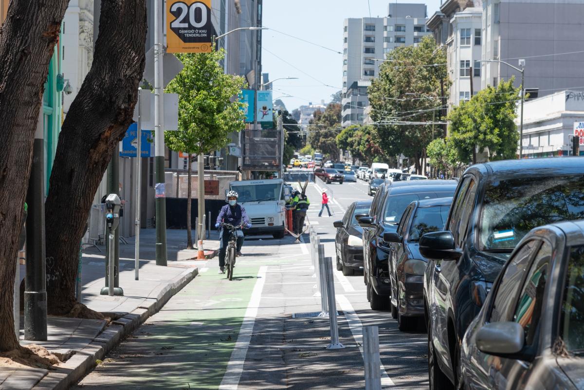
A person rides a bike along the new protected bike lane on Golden Gate Avenue. The lane is painted green, and there are plastic buffer posts between the lane and the parked cars that separate it from traffic. Overhead, a golden-colored sign with 20 on it indicates the new 20 mile per hour speed limits throughout the Tenderloin.

Adding Quick-Builds in the Bayview: After the Bayview Community-Based Transportation Plan was approved by the SMFTA Board in 2020, the first projects were installed this year. Two quick-build projects to improve safety conditions in the Bayview–one on Williams Avenue and one on Evans/Hunters Point/Innes–were completed, along with spot improvements like continental crosswalks. The Quick-Build on Hunters Point Boulevard features concrete barriers painted with murals by local artists.

Expanding San Francisco’s bike network: Over 12 miles of new bike facilities, including 7 miles of new protected bike lanes, were added across the city. Some highlights include a new two-way bikeway on Alemany Boulevard, and a protected bike lane as part of the Folsom Street Quick-Build in SOMA. Nearly five miles of Anza Street have been updated with bikeway markings, speed cushions, and a travel-lane reduction to encourage safer speeds and create an important east-west bike route through the Richmond. You can read more about (and see!) how much San Francisco’s bike network has grown in the last several years in this blog post.
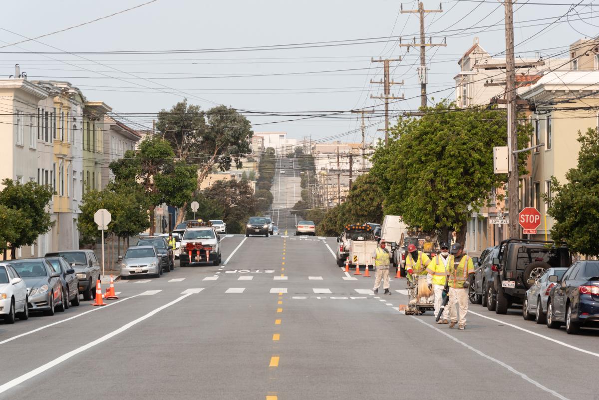
Construction crews striping Anza Street with new bike lanes next to a row of parked cars. The fresh bike lanes are on both sides of the street; there’s a construction truck with cones parked on the left, and cars moving in both directions in the background.

Evolving Slow Streets: Slow Streets have evolved from an emergency response to COVID-19 to one of the SFMTA’s most efficient ways to transform city streets to promote walking, biking, and rolling. In August, the first four post-pandemic Slow Streets–Sanchez, Shotwell, Lake, and Golden Gate–were approved to be extended beyond the pandemic. Sanchez and Shotwell are fully implemented with unique designs informed by extensive community outreach.   

Setting records for traffic calming: The traffic-calming program installed over 233 traffic calming devices across the city–the most ever completed in a year. Traffic calming devices like speed humps, speed cushions, and raised crosswalks make any street safer, and the team worked quickly and efficiently to respond to resident requests for safer conditions on their streets.

Thank you to everyone in the community who has advocated for, championed, and made use of these projects across the city. We look forward to continuing to make San Francisco streets safer in 2022!


Published December 20, 2021 at 09:24PM
https://ift.tt/3GZ9NiN

Wednesday, December 15, 2021

Proposed Bond Introduced to the City’s Capital Planning Committee and the Board of Supervisors

Proposed Bond Introduced to the City’s Capital Planning Committee and the Board of Supervisors
By Benjamin Barnett

Headline graphic of Transportation 2050 - 2022 Muni Reliability and Street Safety Bond

The demands on San Francisco’s transportation system have grown and revenues from transit fares and parking fees have not kept up. The COVID-19 pandemic worsened this problem. New revenue sources to fund our system are needed. The first step is a proposed $400 million Muni Reliability and Street Safety Bond that would support priority transportation capital investments across San Francisco. On Tuesday, December 7, the SFMTA Board of Directors voted to urge the San Francisco Board of Supervisors to place the Bond on the June 2022 ballot. Additionally, the Bond earlier this week was reviewed by City’s Capital Planning Committee and yesterday introduced to the Board of Supervisors.  

The recommended Bond would provide financial resources to improve the transportation system, increase street safety, and meet the long-term needs of the City. Based on both the agency’s infrastructure needs and priorities identified in the SFMTA community survey, as well as outreach, the proposed Bond is focused on keeping Muni equipment and facilities working efficiently, providing quick and convenient transit access, improving Muni service for communities that depend on transit, ensuring Muni service is inclusive and accessible to all, making street safety improvements for people walking and biking.  

The proposed Bond would fund repairs and upgrades to aging bus yards and equipment. This will allow the SFMTA have more modern facilities, maintenance bays and equipment to repair the Muni bus fleet, reducing vehicle breakdowns and supporting reliable Muni service. Additionally, funding on-street infrastructure improvements for public transit will support faster, more reliable, and more frequent Muni service. The proposed Bond would fund improvements to reduce congestion for transit, such as traffic signals that get buses through intersections quickly, wider sidewalks at bus stops for easier, more accessible boarding, and dedicated transit lanes. Finally, the Bond would provide funding to modernize the 20-year-old Muni train control system and leverage substantial state and federal matching funds for the project to increase subway capacity and reduce delays. 

Four circle graphics showing accessibility and services for families, infrastructure, transit including biking, wheelchair and hiking modes of mobility

Bond Components are split across two major programs: 

  1. Make the Transportation System Work Better Amount  

  • Speed up Muni repairs and keep public transit moving by repairing, upgrading and maintaining aging bus yards, facilities and equipment ($250 million) 

  • Enable faster, more reliable, and more frequent Muni service by improving on-street infrastructure for public transit ($26 million) 

  • Increase subway capacity, reduce delays, and deliver dependable, high-frequency transit by modernizing the Muni train control system ($10 million) 

  1. Improve Street Safety and Traffic Flow  

  • Improve safety and visibility at intersections by upgrading traffic signals, signage, and crossings ($42 million) 

  • Increase safety for walking and bicycling and access for Muni connections along major corridors by redesigning streets and sidewalks ($42 million) 

  • Slow speeds and reduce crashes by implementing traffic calming and speed reduction tools ($30 million) 

Transportation 2050 

The Transportation 2050 effort is based on transportation needs and priorities identified by the community over the last eight years through two Mayoral transportation task forces (T2030 and T2045) with additional input from the city’s Muni Reliability Working Group in 2020. Transportation 2050 evaluates the resources needed to achieve the community’s vision for transportation developed through the city’s ConnectSF planning process, as well as infrastructure needs identified in the SFMTA’s 20-Year Capital Plan

The proposed Muni Reliability and Street Safety Bond is just one of the community’s recommended strategies to invest in the transportation system and is only one piece of the funding puzzle.  

Under-investment in transportation has been a decades-long trend. Existing transportation funding draws on multiple local, state, and federal sources, each of which can be uncertain. For example, funding from the city’s Proposition K transportation sales tax or local and federal grants make improvements to our streets and public transit but are not enough and are too variable to address the larger need.  

Transportation 2050 considers a package of revenue sources over several years to sustain a more reliable, affordable, and safer transportation system. Through a combination of local ballot measures, continued state and federal grants, and the development of SFMTA properties, we can put our transportation system on firmer financial footing. If you are interested in learning more, please sign up for regular updates. 


Published December 16, 2021 at 12:51AM
https://ift.tt/3GNsciw

Tuesday, December 14, 2021

Connect SF - A Shared Vision for Transportation in San Francisco  

Connect SF - A Shared Vision for Transportation in San Francisco  
By Emmanuel Stamatogiannakis

As we emerge from the COVID-19 pandemic, what does an effective, equitable, and resilient transportation system for San Francisco’s future look like? ConnectSF, comprised of staff from the SFMTA, the San Francisco County Transportation Authority and the San Francisco Planning Department, has been envisioning just that. Now, after engaging with residents, community groups, businesses, youth organizations, and other stakeholders to gather feedback, the collaborative has released the ConnectSF Transit Strategy. The strategy details how we can reinvest in the city’s transit system to achieve our shared vision of a growing, diverse and equitable city with transportation options that are accessible and affordable to all.   

The Vision  

The ConnectSF Transit Strategy calls for four key investments to build our bold vision of San Francisco’s transportation system:  

  • We will make the current system work better with aggressive renewal and restoration of our current network.   

  • With targeted investments in our street infrastructure, we will deliver a Five-Minute Network that provides reliable service every five minutes on key bus and rail lines.  

  • By renewing and modernizing our rail system, we will build a Modern Muni Metro with increased speed, reliability and capacity for all riders.  

  • We will build more rail to San Francisco’s busiest places to get people quickly and reliably to their destinations. This includes a new subway along Geary and 19th Avenue, an extension of the Central Subway, and a new Caltrain station in the Bayview.  

In order to realize this vision, we will need to invest in creating a system that is better than before – faster, more reliable and more accessible. The ConnectSF Transit Strategy details the big changes we are calling for and where we will need funding to achieve them. Transit is essential to keeping the city moving, and a stable, ongoing funding source will be critical for helping San Francisco manage congestion and rebuild its economy.  

Reshaping Our Transit Network  

Increasing service and making changes that enable new or better transit options are among ConnectSF’s top investment priorities. Our Muni Forward toolkit already includes proven methods for accomplishing this. Bus lanestransit signal prioritycar-free zones and transit queue jumps are just some examples. The ConnectSF Transit Strategy goes beyond these methods and emphasizes the need to prioritize improvements for riders who depend on transit the most.  

The ConnectSF Transit Strategy also calls for reshaping the way we operate transit in San Francisco. San Franciscans need access to a robust network of frequent buses and trains that take them all throughout the city-- rather than focusing primarily on trips downtown. This will require changes along streets and at intersections so that the only time your bus has to stop is to pick you up and drop you off, not to sit in traffic and wait at lights.  

Delivering a modern Muni Metro that residents can rely on also requires catching up with our backlog of deferred maintenance and enhancing our light rail system – for example, upgrading Muni Metro with a new train control system. In the future, in those areas of the city where no amount of bus improvements will be able to meet the demand, long-term planning will also include major new rail projects.  

The ConnectSF Transit Strategy, along with the Streets and Freeways Study, serve to identify projects and policies to be included in the San Francisco Transportation Plan and the updated Transportation Element of the San Francisco General Plan. Rebuilding and advancing our transportation system will take the commitment and involvement of city staff and community stakeholders.  

For more information, please visit www.connectsf.org. 


Published December 14, 2021 at 11:55PM
https://ift.tt/30px3Xw

Friday, December 10, 2021

Approved: 2022 Muni Service Plan

Approved: 2022 Muni Service Plan
By Mariana Maguire

The Muni Service Network proposal for early 2022, and the next steps for the J Church and 48 Quintara, were unanimously approved by the SFMTA Board of Directors on Tuesday December 7, 2021. On Tuesday December 21, SFMTA staff will return to the Board of Directors to outline a phased service change implementation schedule currently slated to begin in February 2022.

SFMTA will restore five routes in full – 6 Haight/Parnassus, 8AX Bayshore A Express, 8BX Bayshore B Express, 28R 19th Avenue and the 43 Masonic – and four routes with some changes – the 2 Clement, 10 Townsend, 21 Hayes and 31 Balboa. Two routes will remain temporarily suspended – the 47 Van Ness and the 3 Jackson. These routes largely overlap other routes that are or will be in service. Instead, improvements that were approved December 7 will help to reduce crowding and wait times on high ridership Muni lines in the same neighborhoods.

The 2022 Muni Service Plan was developed in part through an extensive outreach process. Meetings, open houses, office hours, community pop up events, emails and phone calls with community members helped identify the need to prioritize connections to food hubs and groceries, hospitals and services, and essential jobs for people with disabilities, seniors and lower income communities.

The 8AX Bayshore A Express and 8BX Bayshore B Express were not initially slated for restoration because the 8 Bayshore was already in service. But staff added the 8AX/BX to replace the 8 Bayshore during peak periods after engagement from communities in Visitacion Valley and Potrero neighborhoods. The 8 Bayshore will run less frequently along the Geneva and San Bruno corridors, but Visitacion Valley and Potrero communities will have much needed express service downtown, which will also help reducing crowding on the 8 Bayshore.

Throughout the COVID-19 emergency and recovery, the SFMTA prioritized restoring service to these, and other neighborhoods identified in the Muni Service Equity Plan.

Additional route changes will be implemented as recommended on routes like the 5 Fulton, 12 Folsom/Pacific, 23 Monterey, 57 Parkmerced and others. Many of these changes will increase capacity, reduce wait times and crowding, restore service and prior connections and provide new connections.

Next Steps for the J Church

The J Church will go back into the subway, with some caveats to preserve subway efficiency and avoid the logjams that notoriously plagued the subway pre-pandemic.

J Church frequency will be reduced to every 15 minutes and the Board asked SFMTA to monitor subway capacity as usage increases to reevaluate J Church Metro tunnel service if a threshold of delays is reached.

Accessibility upgrades at the intersection of Market and Church streets will also move forward and staff will study the possible use of historic street cars to provide one-seat service on the J Church to Embarcadero using existing surface tracks as an alternative to running the J Church in the subway tunnel.

Next Steps for the 48 Quintara

Near-term, the 48 Quintara will stay on its current route via Clipper Street. However, SFMTA will move forward with construction necessary to accommodate buses on Douglas Street and then reroute the 48 Quintara to Douglas in the outbound direction (the inbound direction will stay on Clipper Street).

For details of the approved 2022 Muni Service Network proposal, please visit the 2022 Muni Service Network webpage.


Published December 11, 2021 at 12:38AM
https://ift.tt/3dFC9lr

Thursday, December 9, 2021

L Taraval Improvement Project “Segment B” Geared Up for Early 2022

L Taraval Improvement Project “Segment B” Geared Up for Early 2022
By Stephen Chun

Over the summer, we shared the good news that the first segment of the L Taraval Improvement Project was completed on schedule and within budget. A notice to proceed for the next phase of work, Segment B was issued last week to NTK Construction. Project staff is now gearing up for work slated to begin in January 2022.  

What is the L Taraval Improvement Project? 

The L Taraval Improvement Project is a multi-agency collaboration partnered with the San Francisco Public Utilities Commission and the Department of Public Works to improve and upgrade the aging infrastructure. The project will make pedestrian crossing safer, increase accessibility, improve transit reliability, rehabilitate water and sewer infrastructure, enhance landscaping and replace road pavement along the L Taraval line. To lessen the impact to the community, the project was split into two segments: Segment A and Segment B.  

Segment A included 46th Ave. to Sunset Blvd. and was completed in July 2021.   

Segment B will begin in January 2022 and take place along the L Taraval line from Sunset Blvd. to 15th Ave., and on Ulloa St. near West Portal. Work is expected to last through 2024. 

Permanent stop changes will be added to improve safety and reliability:  

  • Taraval St. and 17th Ave. (eastbound) will be relocated from the near side to the far side of the intersection once the new island is constructed  

  • 15th Ave. and Taraval St. (eastbound) will be removed once the boarding island at 17th Ave. is constructed 

  • Ulloa St. and Forest Side Blvd. (westbound and eastbound) will be relocated to Ulloa St. and 14th Ave. 

What to Expect During Segment B Construction  

  • Construction is scheduled to begin in January 2022 and will occur in phases to minimize long-term disruptions 

  • Work hours are scheduled for Monday – Friday, 7 a.m.- 5 p.m. with occasional weekend work*  

  • Substitution of Muni rail service with bus shuttles during portions of the project* 

* subject to change based on construction or operational needs 

Using community input, equipment staging locations were identified: 

  • Santiago St. between 22nd and 24th avenues 

  • 20th Ave. between Ulloa and Wawona streets 

  • Wawona St. between 21st and 23rd avenues 

  • 36th Ave. between Taraval and Ulloa streets 

  • Taraval St. between 12th and 15th avenues 

  • Additional temporary staging locations will be identified over the course of the project 

The project team will be hosting three open houses in the coming weeks. Please join us:  

  1. Monday, Dec. 13, 2021, Virtual Meeting at 6:00 p.m.  

  1. Tuesday, Jan. 4, 2022, In-person Meeting, Taraval Police Station Community Room, 6:00 p.m. – 8:00 p.m. 

  1. Saturday, Jan. 15, 2022, In-person Meeting, West Portal Clubhouse (Lenox and Ulloa), 11:00 a.m. – 1:00 p.m. 

The nearly five-mile-long corridor from West Portal to the Zoo will boast new transit priority traffic signals, bulb outs to make pedestrian crossing safer, new trees, high visibility crosswalks, safety boarding islands and increased accessibility. Once completed in 2024, the Taraval corridor will be more inviting and welcoming for all residents and visitors. 

To follow the progress of this project as we move into the next phase, please visit the project webpage and sign up for updates.  

For questions or comments, please email LTaravalProject@SFMTA.com or call 415.646.4771. 


Published December 10, 2021 at 12:44AM
https://ift.tt/3IxaQrM

Friday, December 3, 2021

Fulton Street Sees Transit and Safety Improvements

Fulton Street Sees Transit and Safety Improvements
By Shalon Rogers

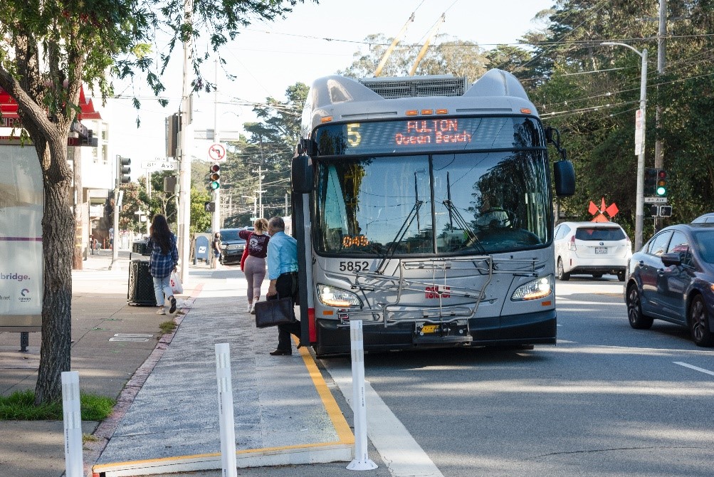
Photo of a 5 Fulton bus boarding passengers at a temporary transit bulb at 8th Avenue and Fulton, A temporary transit bulb was recently installed at 8th Avenue and Fulton, reducing travel time for the 5 Fulton and 5R Fulton Rapid and making boarding safer.
For those who ride the 5 Fulton or 5R Fulton Rapid in the Richmond District, you may have recently noticed something new about the bus stops on Fulton Street at 6th and 8th avenues. And perhaps you noticed that your bus ride seemed to go slightly faster or with less disruption.

Two new temporary transit bulbs installed at 6th Avenue eastbound and 8th Avenue westbound bring safety and transit benefits to Fulton Street in advance of the planned construction of permanent bulbs and are part of the Fulton Street Safety and Transit Project.

Six permanent transit bulbs between Arguello and 10th Avenue are ultimately planned, which will save time and improve reliability for riders on the 5 Fulton and 5R Fulton Rapid by reducing the time it takes for buses to pull in and out of traffic. The planned bulbs are all located at major entrances to Golden Gate Park, as well as on a stretch of Fulton Street that is part of San Francisco’s High Injury Network, the 13% of city streets that account for 75% of severe and fatal injuries. Both Muni riders and people who walk will benefit as the bulbs will expand the waiting area for riders, improve access for people with mobility needs and improve visibility for people walking.

With the installation of these temporary bulbs, we will have completed Muni Forward transit reliability upgrades along the entire route of the 5 Fulton and 5R Fulton Rapid – the first Muni lines to achieve this distinction. The bulbs add to over a decade of improvements to these lines, including:

  • Installed bus bulbs, traffic signals that stay green longer for buses, and other Muni Forward reliability upgrades on McAllister and outer Fulton (2017-2018)
  • Introduced 60’ buses on the 5 Fulton and 5R Fulton Rapid to reduce crowding that will be returning to service soon (2016-2017)
  • Upgraded and expanded transit lanes on Market, Fremont and Beale streets (2014-2021)
  • Launched the 5R Fulton Rapid, reducing travel times from the Outer Richmond by up to seven minutes (2013)
  • Made McAllister a two-way street, saving three minutes per trip (2011)
  • Extended evening service to Transbay Terminal (2009)

Additional safety improvements that have recently been completed on Fulton Street include daylighting (removing parking) at 34 intersections between Stanyan and La Playa streets and the installation of 13 painted safety zones. These enhancements improve visibility for drivers and make it safer for people walking. Soon we expect to install speed radar signs between 38th and 39th avenues and 40th and 41st avenues which will help reduce speeding and improve safety.

The project recently received additional funding with the help of Assemblymember Phil Ting, who secured $1.6 million from the state budget to be used on improvements along Fulton Street. Combined with a Caltrans Low Carbon Transit Operations Program allocation and Proposition K sales tax funds from the San Francisco County Transportation Authority, this funding will allow for improvements that will benefit tens of thousands of Muni riders and make Fulton Street a safer place for people walking.  


Published December 03, 2021 at 10:13PM
https://ift.tt/3xOyLy1

Tuesday, November 30, 2021

A Green Light for Muni Customers

A Green Light for Muni Customers
By Stephen Chun

Have you ever been on a Muni vehicle and realized that if the light had only stayed green for just a few more seconds you wouldn’t have been trapped at a red light? SFMTA’s Connected Corridor Pilot approached this problem with a new state of the art solution.  

Most signals in San Francisco do not have sensors to detect vehicles at an intersection. However, through a grant from the U.S. Department of Transportation, our project team was able to test an advanced technology for signal timing based on who is present at an intersection. In this way, transit platform and traffic signal sensor data can be used to activate signal timing adjustments, responding to traffic conditions in real time. These adjustments provide more opportunities for transit vehicles to make it through intersections on a green light.   

The project team turned on the adaptive signal timing program during several days in July and August 2021, with traffic engineers and traffic signal electricians monitoring intersections both in-person and by observing traffic cameras. Our priority was to reduce transit vehicle travel times. Once in place, we compared travel times for trains both before and after the new technology was implemented.  

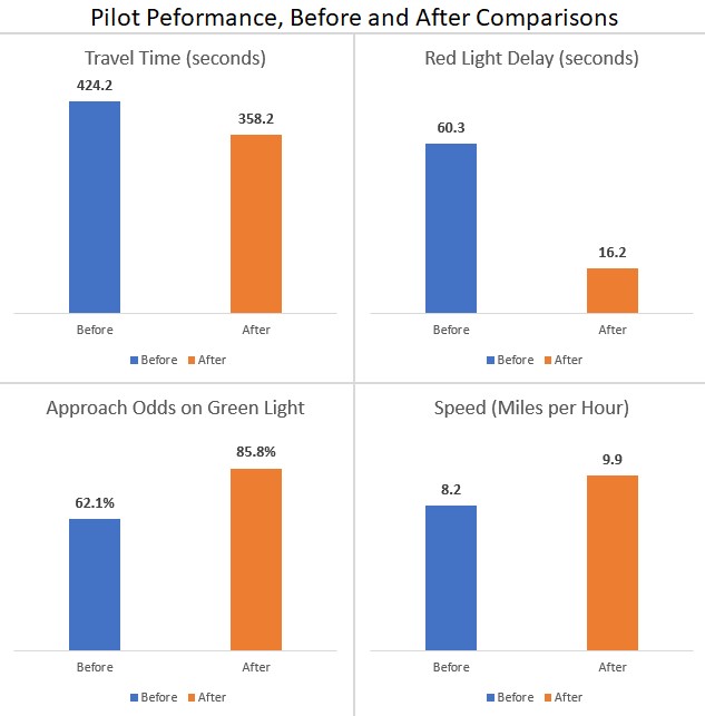
We found that with our pilot project, the average light rail vehicle (LRV) travel time along the 1-mile corridor was reduced by 66 seconds, resulting in an average travel speed increase of 21% from 8.2 miles per hour (MPH) to 9.9 MPH. With this system, the chance that a train will reach an intersection on a green light improved from 62.1% to 85.8%, meaning almost no red-light delay.     

Connected Corridor - Pilot Performance, Before and After Comparisons

Figure 1. Pilot Corridor Performance, Before and After Comparisons 

During the pilot, 60% of LRV corridor trips had 10 seconds or less of red-light delay, compared to only 5% previously.  In fact, 20% of trains saw no red-light delay at all on the corridor, compared to the previous study period when not a single train avoided red light delay entirely.   

Improving signal timing for just one specific mode or direction can potentially result in negative impacts for others.  To evaluate this, we measured travel impacts to pedestrians and non-Muni vehicles to evaluate the potential effects from prioritizing transit.  Fortunately, our data show that there was a 1% increase in the overall odds that other vehicles would encounter a green light and only a 1% increase in the odds that pedestrians would reach an intersection on a Do Not Walk symbol. 

Vehicles on side streets were generally unaffected unless they were also held to prioritize train through traffic. Heavier volume side streets such as Mariposa Street had increased average wait times of up to 78% for vehicles, from an average wait of 46 seconds previously, to an average wait of 87 seconds during the pilot. Fortunately, the adaptive signal system only increased the average wait time by 4 seconds for pedestrians if they arrived on a Do Not Walk symbol, from 22 seconds to 26 seconds.  Further refinement of the signal timing logic could help address these concerns. 

With detailed information collected through the advanced sensors, our project team was able to make refinements and real-time signal timing adjustments that account for time of day, direction of travel, and the real-time volume of pedestrians, vehicles, and transit vehicles.  

These promising results will lead the SFMTA to consider applying this technology in other locations to better understand how the system could work more widely around the city and any trade-offs that could arise in regard to overall traffic flows. 

Looking forward, we are also exploring other new technologies. For example, the LiDAR (sensors that use lasers to identify objects) used in this project provides a new way to capture and classify objects at intersections, but there may be a need for additional sensors or different mounting locations to improve detection accuracy. Project staff will build upon the lessons learned from the pilot to inform future efforts to optimize the signal timing to make our streets better for all users.   


Published December 01, 2021 at 02:31AM
https://ift.tt/31fWtr4

Photo Exhibit Event: Vintage Bus Display and Tour

Photo Exhibit Event: Vintage Bus Display and Tour By Jeremy Menzies Join us Saturday, Jan. 27 at a special event for our exhibit, " 1...